Hiking Headley Overlook and the Ogden Mine Railroad in Spring.
It was Memorial Day so we wanted to head away from the traffic and the beach. We thought we were taking a gamble going to Mahlon, as there are campgrounds there, but we only saw a handful of people.
7.5 miles – Easy-moderate… first half on the Highlands trail was more rugged than the 2nd half on the Pine Swamp trail. Ogden Railroad is flat, level, cinder path.
Route: Highlands Connector Trail (Black on Teal Diamond) to Highlands (TEAL diamond/Highlands tag) to Pine Swamp Trail (White) to Boulder Trail (unmarked) to Ogden Railroad (unmarked)
Deatailed hike guide on our main Headley Overlook page.
A good shorter hike would be to just do the Pine Swamp Loop from the main parking lot; that would be 3.8 miles with options to bail along the way.
The first part of this route has a view point at Headley Overlook of Lake Hopatacong and lots of greenery towards the east.
The view is nice but somewhat limited and not as grand as some viewpoints in the state – but worth checking out anyway.
The Pine Swamp loop has no views but is nice, easy hiking and passes the “highest point in Morris County” at 1395′.
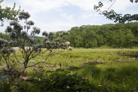
We opted to take the Ogden Mine Railroad on the way back to check it out. We were concerned it could be a bad choice if the rail bed was out in full sun (it was in the upper 80s and very sunny out), but it turned out to be fully shaded.
The surface was flat and level, and actually quite pretty as it passed several swampy areas. We even spotted a Great Blue Heron by the water, before it swooped off into the trees.
Parking: This route starts from the lot near Saffron Pond. Rt 287 to Rt 80 W. Exit 34 to Rt 15 North. Right onto Weldon Road. Large parking area is on the right. (You will first pass a park sign and driveway that goes to another lot)
Restrooms: Porta-john in the parking lot. There is another porta and camp-style restrooms (composting toilet in a building) at the picnic parking area, just after the trail crosses the road.
Map: There were maps in the kiosks, but it’s best to print one ahead just in case.