Short hike to Silver Spray Falls, also called Hidden Falls.
Consider combining a hike here with a stop at Buttermilk Falls and/or a short hike at Tillman Ravine on the way.
| 1.5 miles | This guide: Detailed instructions and photos follow below. |
| Nearby, same lot | 0.2 – Buttermilk Falls (waterfall only) 7.2 – Buttermilk Falls, Crater Lake, Hemlock Pond |
| Alternate/Winter | If walking Mountain Road from: 3.5 total, round trip – Walpack Cemetery; noted below. 4.5 total, round trip – Haneys Mill Road; noted below. |
| Nearby | Tillman Ravine, Van Campens Glen; Millbrook Village and Van Campens Glen; Blue Mountain Lake Loop; Appalachian Trail – Crater Lake to Blue Mountain; Crater Lake and Hemlock Pond Loop. |
Our two cents:
Unlike nearby Buttermilk Falls, this requires a short hike on an unmarked trail that can be hard to navigate and has a potentially tricky stream crossing.
Silver Spray Falls is also called “Hidden Falls” because the trailhead is hard to spot and the falls themselves are tucked away. People sometimes don’t find them on the first attempt so we’ve created this guide to help.
This waterfall is not recommended for inexperienced hikers or families with very young children.
Updated: 3/2026 – Minor edits; not re-hiked.
Hike Info:
Map:
Kittatinny Trails map set covers the area or use the map on the park site. Follow along on your smartphone with our Interactive Map link above.
How to get to Silver Spray Falls
Silver Spray Falls is on Mountain Road between Walpack Cemetery and Haneys Mill in Layton, New Jersey and is within the Delaware Water Gap National Recreation Area.
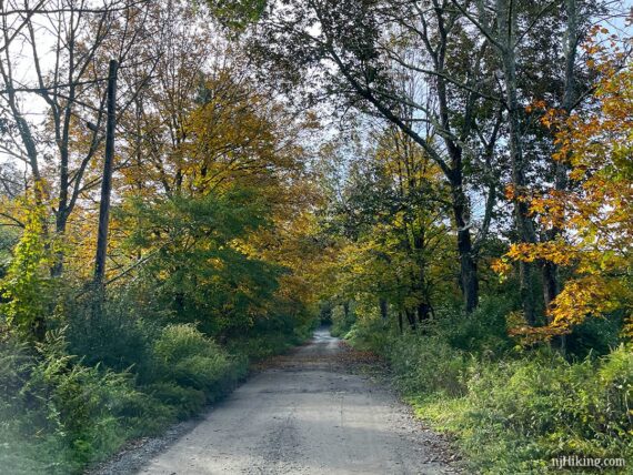
Parking is at the same lot as Buttermilk Falls. There are several approaches which can vary due to closures for winter or road/bridge damage. Road names may vary depending on map source, and they aren’t always marked on the road.
We’ve provided a coordinate link for the parking lot and address for a GPS – but the actual approach will depend on where you start and any closures in effect.
Check the Delaware Water Gap park site (link above) for current road closures before setting out.
Parking: N41.13702° W74.88917°
Buttermilk Falls Trail Parking, Mountain Road, Layton, NJ 07851. This is a park road and doesn’t have a street number. This phrase entered into Google Maps should work.
!! DOUBLE CHECK the route that Google (or other navigation) is directing. While this is the correct coordinate link and address of the parking lot on Mountain Road, Google etc may direct incorrectly, especially if it thinks a road is still seasonally closed. It may instruct to park on an adjacent road and walk through woods without a trail – do not do this!
Winter: Silver Spray is usually a half mile walk from the parking lot/Buttermilk Falls – except during the winter. Mountain Road is one of the roads in the park that are closed to vehicles from January 2 (or at first significant snowfall) until April 15 (open date may vary).
If Mountain Road is closed to vehicles you can walk down the road to access the falls. Park at Walpack Cemetery or at the other end, Haneys Mill Road. Other roads may be closed before this which affects where you can park.
Mountain Road / Parking Lot
Mountain Road is a dirt/gravel road that has bumps and potholes, possibly deep ones. It’s usually fine with a regular car if you take it slow – but if you tool around in a really sweet ride you may want to have someone else drive :) or park at either end and walk down Mountain Road to the waterfall.
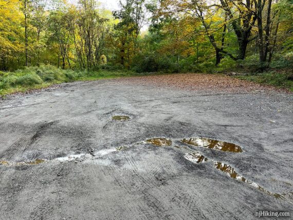
Approaching from either direction on Mountain Road, turn into the parking area for Buttermilk Falls:
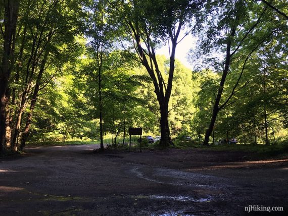
The dirt lot for Buttermilk Falls often fills to capacity and may be wet or muddy. An empty lot in early morning:
Restrooms:
None at the parking lot. If you approach from Rt. 206 to Tilman Road to Walpack Cemetery, you’ll pass outhouses at the two Tillman Ravine parking lots on Tilman Rd.
If you approach from another direction that passes Millbrook Village this has restrooms in season and possibly portable toilets otherwise.
Related: Waterfalls in NJ / Best Waterfall Hikes in NJ
Hike Directions:
These directions are from the Buttermilk Falls parking lot. If there are winter closures and you:
- Parked at Walpack Cemetery = Silver Spray trailhead is 1.5 miles down the road, on the left.
- Parked at Haneys Mills Road = Silver Spray trailhead is 2 miles down the road, on the right (0.5 past Buttermilk).
- From either way, the loop to the waterfall is 0.5 total round trip.
0.0 – When facing Buttermilk Falls, turn left and walk down Mountain Road.
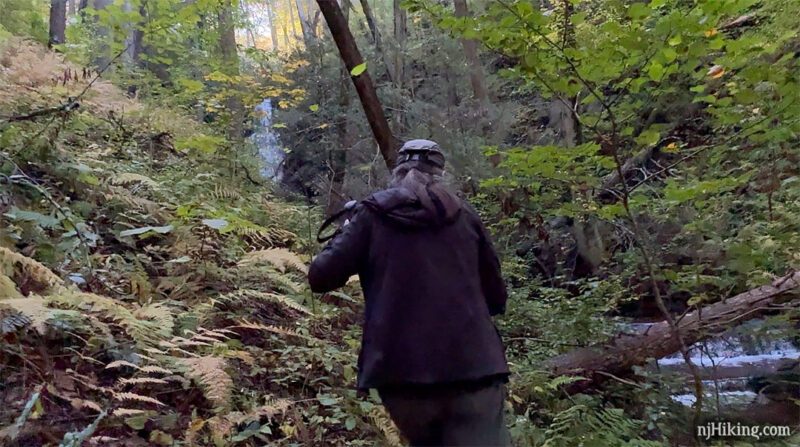
0.5 – The trailhead is a nondescript small pull off on the right. Start following the unmarked trail, which might not be visible from the road.
0.6 – Keep left on the unmarked trail and cross the stream. [There is also a path that continues ahead that doesn’t cross the stream – but you won’t see the falls much if any that way.]
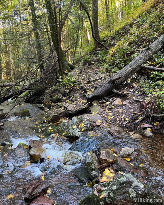
There might be rocks stacked across the stream or look for the best spot to cross on assorted branches and rocks. Might need to look up or down stream a bit.
The crossing had a row of rocks last time we hiked here (10/2023). Constantly flowing water could potentially alter things at anytime.
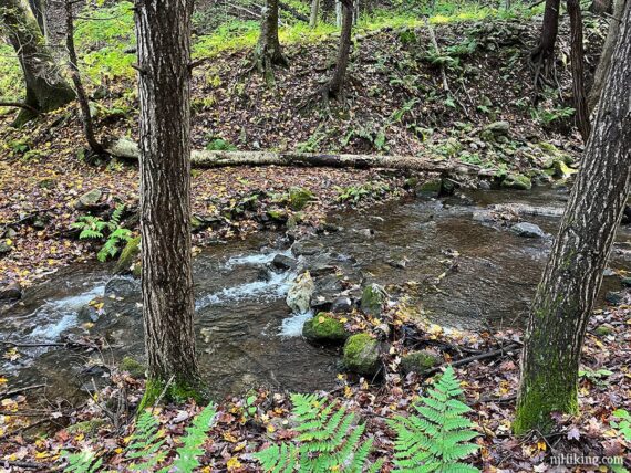
Trekking poles are handy but there’s usually a decent stick left nearby by others. If the water is flowing really high or fast it might be too dicey to be worth it. If so, consider bailing and revisit another day.
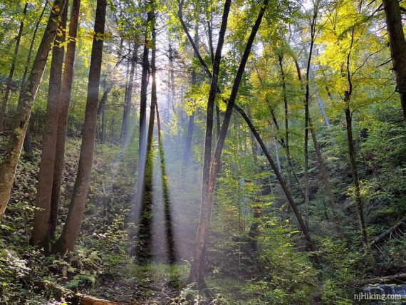
Once on the other side of the stream, continue following the unmarked trail. Cascades appear on the stream and the top of Silver Spray Falls peeks through the trees.
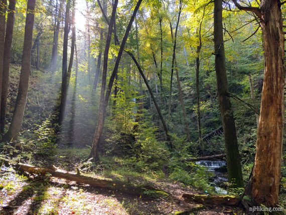
0.7 – Start veering RIGHT towards the cascade and find the trail along the stream – it may not be very obvious. You might need pick your way over branches and then over wet rocks to get in front of the waterfall.
This is looking back at the trail and rocks after getting over to stand in front of Silver Spray Falls:
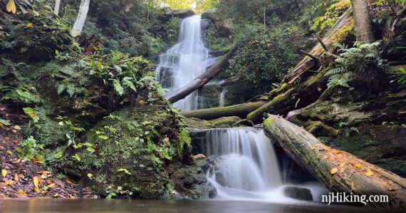
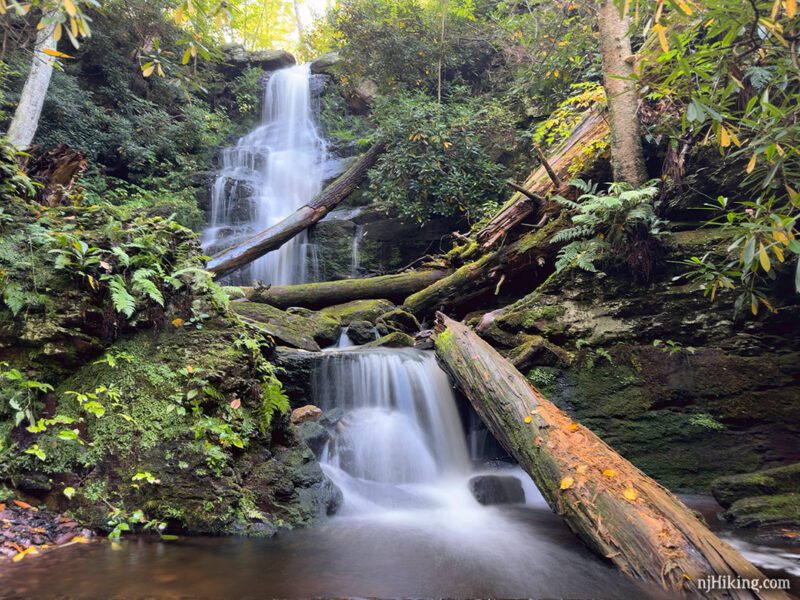
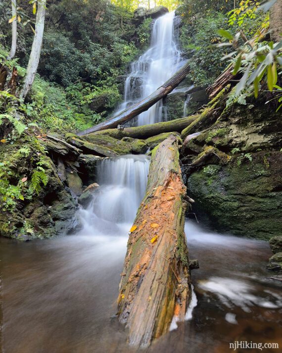
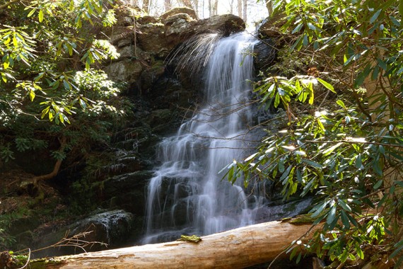
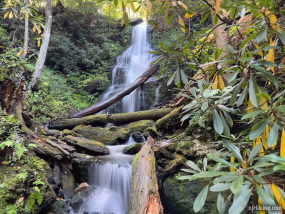
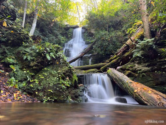
The beautiful falls are nestled in a little alcove with the main tier at the top cascading into a second tier before pooling a little at the base. Fallen logs and branches lay across the falls.
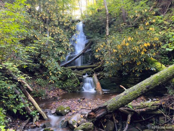
Delicate wisps of water cascade over the rocks. Watch for the spritzes and namesake spray off the top of the waterfall (these 2 shots are from 2016 so the log positions are different).
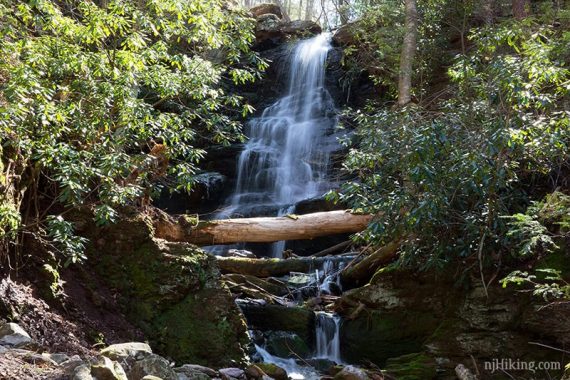
Like Buttermilk Falls just around the corner, rhododendron surround the falls. Time it just right and catch the rhododendron blooming. During fall foliage season the leaves turn golden yellow.
These are one of our favorite waterfalls to photograph but it can be a little tricky finding a good spot to frame the shot. The small area is wet with rocks and branches to maneuver around.
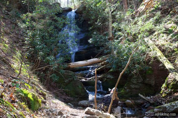
Wider shot of the area with a person to get an idea of the scale of the waterfall (taken 4/2016).
When ready, retrace the unmarked trail back and cross the stream again.
When back at Mountain Road, turn LEFT to walk back to Buttermilk Falls (or if you parked on Haneys Mills Road) or turn RIGHT to walk back to Walpack Cemetery.
—
Hiked: 10/1/23. with a stop at Buttermilk Falls; plus Stony Lake and Falls
Hiked: 4/10/16. Silver Spray Falls and Buttermilk Falls only, for photos.
Hiked: 6/15/13. After main Butter hike but stream too high to get to it. Trail Blog: “Buttermilk Falls, Crater Lake and Hemlock Pond Loop“