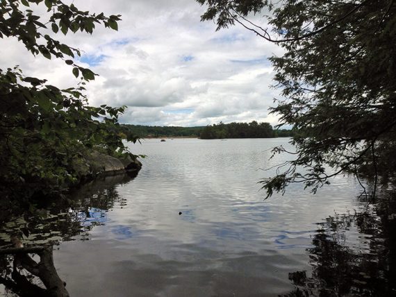
Shady hike through plentiful rhododendron, a cedar swamp, and past Lake Lookout and Wawayanda Lake.
8.2 or shorter options, total round trip. Minimal rocks, not a lot of elevation gain. Some potentially wet areas.
- Shorter: 2.6 –Wingdam with return via Laurel Pond; rhododendron and lake views.
- Variation: 6.5 – Remove the loop to Lake Lookout; return Laurel Pond; noted below.
- Variation: 7.1 – Remove just the loop to Lake Lookout; noted below.
- Nearby, boat lot: Furnace Loop; Lake Loop.
- Nearby, beach lot: Lake Loop and Twin Bridges.
- Nearby, visitor lot: Hoeferlin, Cedar Swamp, Red Dot; Iron Mountain and Hoeferlin Loop.
- Nearby: Old Coal Trail, Lookout Lake, Laurel Pond Trail.
- Alternate: Wawayanda Lake Kayak.
Hike Info:
Our two cents:
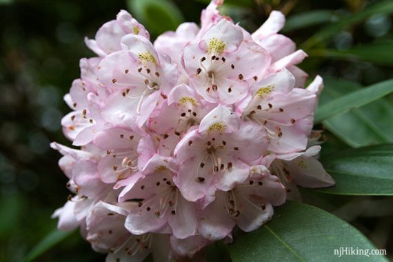
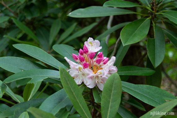
This shady hike is all about rhododendron thickets and tunnels, which bloom in late June/July. However, rhododendron are evergreen so this hike is nice any time of year.
Extensive network of trails that allow this route to be easily shortened or extended and are noted in the description.
Note: This popular park often fills to capacity in summer and temporarily closes. Bonus fun: canoe rentals available in season, or bring your own.
Updates: 6/2022 – Re-hiked; minor edits, added photos; Cherry Ridge Road is now unmarked and no longer blazed WHITE zig-zag on BLACK. 2/2022 –Trail map info. 4/2021 – Not re-hiked; description updated to reflect major changes to trail names near the lake.
Map/Books:
Northern New Jersey Highlands Trails Map is recommended to navigate the network of trails in this park. A similar route is in 50 Hikes in New Jersey. Others are in Hiking New Jersey (2023), Hiking the Jersey Highlands, 60 Hikes Within 60 Miles: New York City.
Parking: N41.18860° W74.42673° [Boat Lot]
“Wawayanda Boathouse”, Boat Launch, Highland Lakes, NJ 07422.
From the south: 287N to exit 55 towards 511/Wanaque/Pompton Lakes. Right at bottom of the ramp and follow 511/Ringwood Ave/Greenwood Lake Turnpike through town.
The road will curve left and pass Monksville Reservoir and then Greenwood Lake. The road name changes to Warwick Turnpike.
The park entrance on the left, about 19 miles since getting on 511. Drive past the visitor center lot (fee gate in season) and follow the park road for a bit.
Turn left at the sign for Wawayanda Lake. Drive through the first parking lot (for the beach), and continue to the boat launch lot.
Note: Google and GPS software may direct you to the auxiliary entrance near Barry Lakes instead of the main entrance. This gate may be open seasonally, only weekends/holidays, with limited hours (check the park site). If it’s closed you’ll either need to hike from that lot over to the boat launch lot or drive back around.
Google/GPS may also show several of the trails in Wawayanda as drivable roads… they aren’t. Driving is allowed on part of Cherry Ridge but you really don’t want to drive through the park.
Wawayanda charges an entrance fee Memorial – Labor day; which is covered by the NJ State Park Pass.
Restrooms:
Regular bathroom in the main lot by the visitor center and at both Wawayanda lake parking lots – the first (beach lot) and the second (boat launch lot).
Composting toilets are by the Furnace which is near the junction of Laurel Pond and Double Pond trails.
Hike Directions:
Overview: Lake Loop (ORANGE) – Double Pond (YELLOW) – Cedar Swamp (BLUE) – Banker (GREEN) – Cherry Ridge Road (Unmarked) – Old Coal (RED) – Lookout (WHITE) – Cherry Ridge Road (Unmarked) – Laurel Pond (YELLOW) – Lake Connector (YEL-ORG) – Wingdam (BLUE) – Lake Loop (ORANGE)
Note: Trail names are often on the markers, in addition to the color.
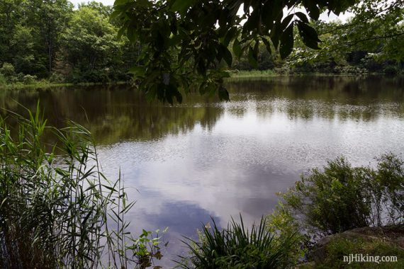
0.0 – Facing the lake from the boat launch parking lot, turn LEFT and walk on a path along the lake that is part of the Lake Loop (ORANGE).
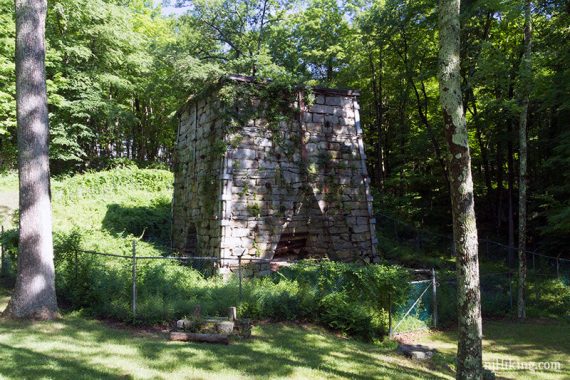
0.3 – Cross a wooden bridge just before the Wawayanda Furnace.
Fun Facts: The Wawayanda furnace was built by William Ames in 1846 and used to smelt ire ore from local mines from 1846 to 1857. It measures 37 feet high by 30 feet wide. Ore, charcoal, and limestone were loaded into the top of the furnace via a pushcart and a ramp on the hillside.
A water-powered bellows on the right provided the heat to melt the ore. Seven tons of iron were produced daily and was of such good quality that it was used to make train wheels. [Source: Park sign, circa 2016]
Facing the composting toilets, turn LEFT and follow the park road across a bridge. [Don’t take the other yellow trail at this intersection, Laurel Pond].
Follow the park road as it curves to the left to go through the camp area – yellow blazes appear for Double Pond (YELLOW). Follow Double Pond (YELLOW) as it heads away from the campsites and on to a trail.
0.8 – Soon, cross over a bridge with water on either side – and possibly on it. A three plank wide section has been added to be above the water.
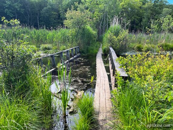
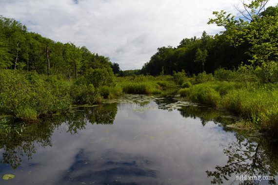
The bridge crosses Lake Lookout Brook… which is coming from Lake Lookout that will be reached on this route eventually.
0.9 – Pass RED DOT on the right.
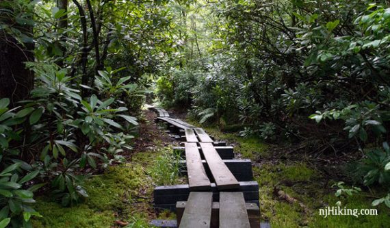
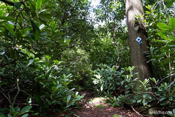
1.3 – Veer RIGHT and now follow Cedar Swamp (BLUE). In a bit, a long plank boardwalk starts.
The last time we hiked this, in 2016, trail maintainers were here getting ready to repair the boardwalk. The old planks were super slippery then, but now they have pieces of grippy roofing tiles tacked to them.
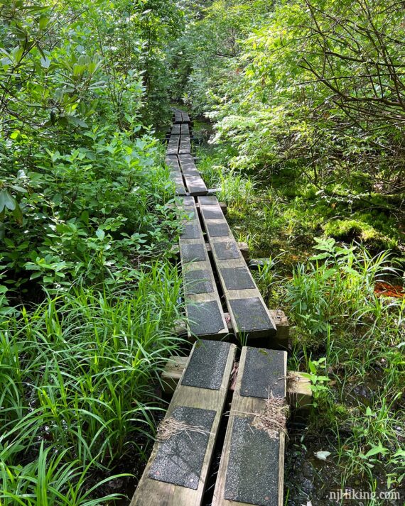
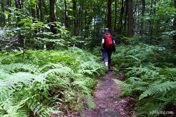
The boardwalk is very long and just keeps going and going through a mass of rhododendron thickets. These form a tunnel that sometimes towers overhead.
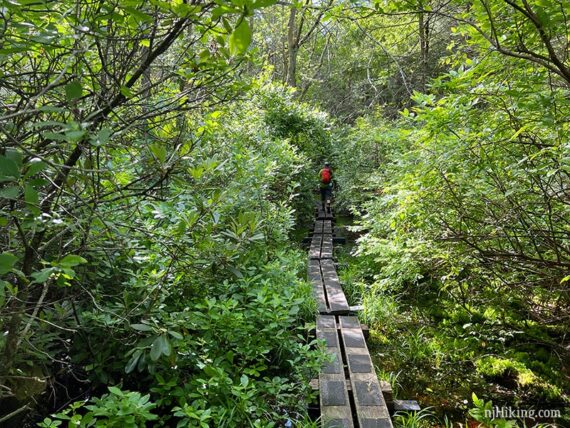
If you time it just right in late June or July you’ll be treated to tons of pretty rhododendron flowers.
It’s not hiking in Jersey unless there is a rusted car along the trail… watch for one nestled in the ferns off on the left, when the trail takes a right turn.

2.6 – Continue on Cedar Swamp (BLUE) as it turns LEFT at a T-intersection.
2.7 – Veer RIGHT and now follow Banker (GREEN), a woods road. [Banker (GREEN) also goes left].
3.1 – Arrive at a small dirt parking area at the intersection of Banker and Cherry Ridge Road. Cherry Ridge Road is dirt road accessed off of Clinton Road and is marked as “rough” on the trail map but there are often vehicles parked here.
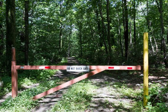
Turn RIGHT and now follow Cherry Ridge Road (Unmarked). [Banker (GREEN) ends]. In a bit, continue past a gate.
Cherry Ridge Road is a wide flat dirt road for awhile. This is either a bit of a break or a bit boring, depending on your tastes.
4.0 – Pass RED DOT on the right. Soon, cross a bridge. Looking left off of the bridge we spotted a small stone bridge over the stream but didn’t check it out. There are many other unmarked trails in the area to explore.
4.1 – Turn LEFT and now follow Old Coal (RED) past a large gate.
Variation: Continue straight on Cherry Ridge instead, and then turn RIGHT onto Laurel Pond (YELLOW), picking up the directions at 5.7 below. This cuts 1.1 miles out of the hike.
4.5 – Veer RIGHT and now follow Lookout (WHITE). [Old Coal (RED) continues to the left.]
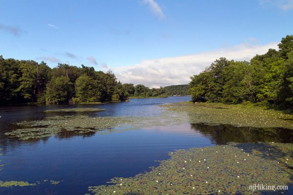
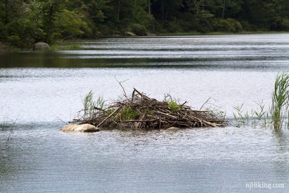
4.9 – Lookout (WHITE) skirts the edge of the Lookout Lake.
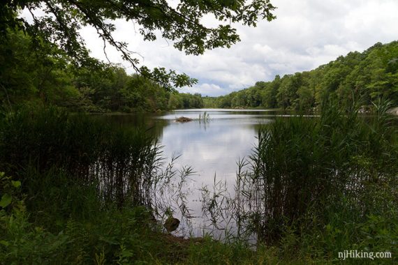
There may be a beaver dam visible out on the lake.
Continue to the corner of the lake where there is a rock that makes a nice break spot.
5.0 – Continue following Lookout (WHITE) as it veers right where there is a large interesting boulder on the left. [An unmarked but prominent trail continues straight].
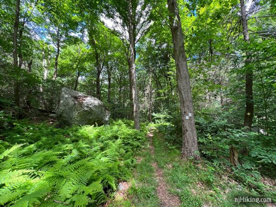
Lots and lots of ferns through this section.
5.5 – Turn RIGHT and now follow Cherry Ridge Road (Unmarked). [Lookout (WHITE) ends. Cherry Ridge Road also goes left].
5.6 – Turn LEFT and now follow Laurel Pond (YELLOW) – the sign might not be obvious until turning and taking a few steps.
5.9 – Turn LEFT and now follow Lake Connector (YEL-ORG). There isn’t a sign, just markers once you turn, so it might be easy to miss if you’re distracted by discussing what to get as your post-hike treat (if you’re undecided: opt for ice cream. Preferably chocolate chip mint. The green kind).
Variation: Instead, keep following Laurel Pond (YELLOW) back to the furnace area and then turn left to head back to the lot. This removes .6 mile from the hike.
6.3 – Start following Lake Loop (Orange). Lake Connector (YEL-ORG) ends and merges into Lake Loop (Orange), we didn’t notice the change last time. Lake Loop (Orange) eventually starts to hug the shoreline where are a few flat rocky break spots with views of the lake.
7.3 – Turn LEFT to now follow Wingdam (BLUE) which is co-joined with Lake Loop (Orange). [Wingdam (BLUE) also goes right.] Cross a bridge over a spillway.
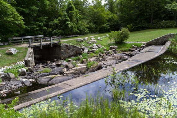
Just after, Lake Loop (Orange) leaves to the left [Option: Take this to get more views of the lake, the trail meets back up in just a bit]. Pass the dam at the end of the lake, turn LEFT on the main path to head back to the parking lot.
—
Hiked: 6/18/22.
Hiked: 7/10/16. Trail Blog: “Wawayanda Rhododendrons in July“