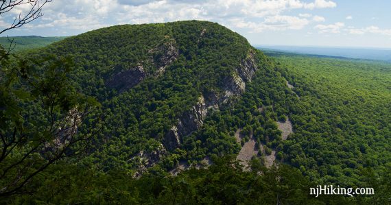
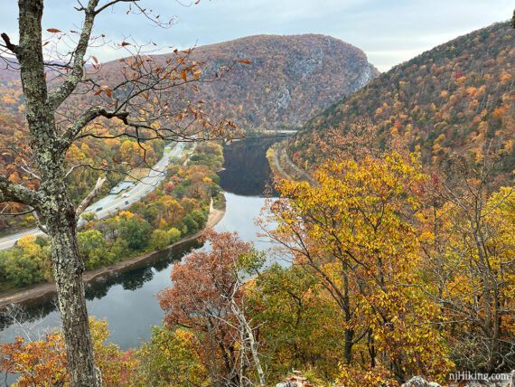
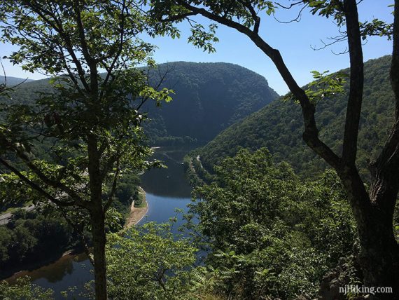
Wonderful view of New Jersey’s Mt. Tammany and the Delaware River from this short, steep route.
5.1 miles, total round trip. Steep and rocky; rock hop over a small stream. The return route is on a woods road (Mt. Minsi Fire Road) and is more gradual but still quite rocky.
| 5.1 miles | This hike guide: Detailed instructions, photos, and video follow below. |
| Variations | Noted in the description below. 4.0, out-and-back on the A.T. to the 2nd viewpoint. 4.5, stop at the 2nd viewpoint and return via Mt. Minsi Fire Rd. 4.6, out-and-back on the A.T. to the 3rd viewpoint. 5.3, include Caldeno Falls and Table Rock. |
| Longer | Add some miles with the Appalachian Trail, we did a 16.6 mile version years ago. Or keep going, the AT south ends in Georgia… |
| Challenging version | Check out our “Mind The Gap” hike – Mt. Minsi and Mt. Tammany in one day. |
| Nearby | Mt. Tammany; Sunfish Pond; Mt. Tammany and Sunfish Pond; Appalachian Trail – Sunfish Pond to Raccoon Ridge; Sunfish Pond – Garvey Springs and Douglas Loop. |
Our two cents:
The best view of New Jersey’s Mt. Tammany is actually from Mt. Minsi, on the Pennsylvania side of the Delaware Water Gap – the break in the Kittatinny Mountains that was carved by the Delaware River.
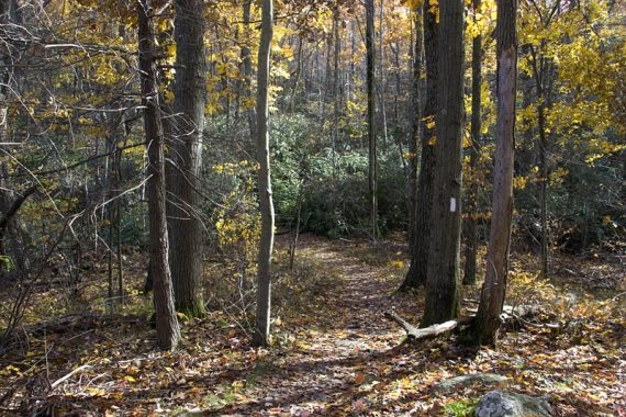
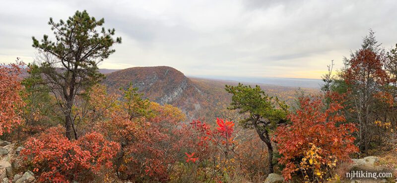
One of the Best Fall Foliage Hikes near New Jersey. Plenty of rhododendron that bloom in July. This is a popular route. Some road noise early on that dissipates as the trail climbs.
Updated: 5/2025 – Updated shuttle info. 12/2024 – Minor edits; added links to historical photos of Caldeno Falls. Older change log at page bottom.
Hike Info:
Map/Books:
Use Kittatinny Trails. Follow along on your smartphone with our Interactive Map link above.
Variations with detailed description and map diagrams can be found in Hiking Pennsylvania and Hiking the Poconos. Kittatinny Trails has details about the trails but not a loop hike.
Parking: 40.979754 -75.142189
“Parking for Appalachian Trail to Mount Minsi” if using Google. No street address for this lot. For the nearby intersection of 611/Main St. with Mountain Road try the location of the Deer Head Inn – “5 Main St, Delaware Water Gap, PA 18327”. The lot is just down from the inn on Mountain Road.
From Rt. 80 West, go over the toll bridge into PA. Stay to the right for PA Exit 310/Rt 611 South (immediately after the toll there is a road on the right that looks like an exit, but is not).
Follow signs for Route 611 South and PA Welcome center to a circle. Continue to the Welcome Center for restrooms first, or continue around the circle onto Broad Street.
From the circle, follow Broad Street through town, then turn left onto Main St. Turn right at the Deer Head Inn onto Mountain Road. Take the next dirt road on the left into the trailhead parking area.
The small dirt lot fills up fast. If full, continue through the one-way lot to a few more spots in a smaller lot just past the main one. There is no parking allowed along Mountain Road so if there are no spots, you’ll have to circle around or hike elsewhere.
Seasonal Hiker Shuttle (Free): Runs in season between DWG Park and Ride and the apple pie bakery (flag stop). You’ll need to walk ~0.6 miles from the Village Farmer and Bakery to the trailhead but can conveniently get tasty provisions before or after your hike. Check www.gomcta.com for schedules and routes.
Restrooms:
None at the trailhead. The PA Welcome Center just over the bridge has bathrooms; unsure of the hours but it was open early AM. Before leaving NJ there is a rest area on Rt. 80 W, Delaware Water Gap Travel Plaza.
Hike Directions:
Overview: Appalachian Trail (WHITE) – Mt. Minsi Fire Road/Lake Road – Appalachian Trail (WHITE). Note: the Mt. Minsi Fire Road is named Lake Road on some maps.
For this route, we reference three overlooks:
- 1st: on the Appalachian Trail heading up, with an approaching view of Mt. Tammany. Called “Lookout Rock” on maps.
- 2nd: the main viewpoint, of Mt. Tammany.
- 3rd: further up on the Appalachian Trail, with a view east into northwestern NJ, the Delaware River, Pennsylvania – and not of Mt. Tammany.
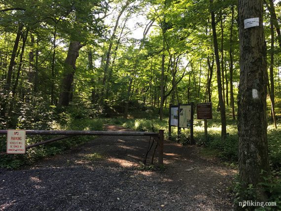
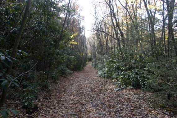
0.0 – From the trail kiosk, start following the Appalachian Trail (WHITE) on a wide unmarked woods road which is also Mt. Minsi Fire Road/Lake Road.
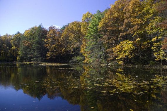
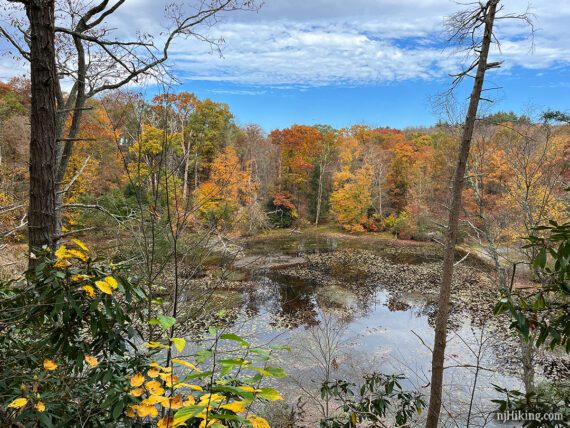
Small Lake Lenape comes into view shortly. There’s a bench at the edge of the lake.
0.4 – Veer LEFT off of the woods road to continue following Appalachian Trail (WHITE) onto a rocky trail. [Mt. Minsi Fire Road/Lake Road continues ahead].
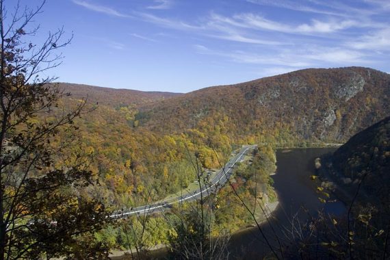
0.4 – Soon, get a peak at the Gap from a limited view – Mt. Tammany on the left, Rt 80, the Delaware River, and Mount Minsi on the right.
In just a bit more is a now mostly obscured view marked as Council Rock on some maps.
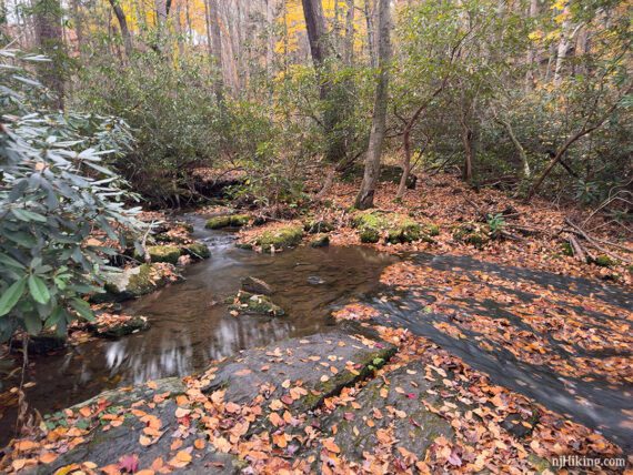
1.1 – Eureka Creek spills across the Appalachian Trail (WHITE) – cross it with a minor rock hop.
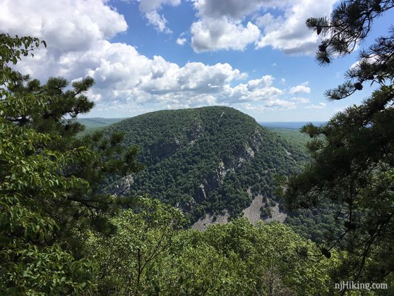
1.3 – Where the Appalachian Trail (WHITE) turns right, first briefly continue ahead on a casual path to the 1st overlook, Lookout Rock. The Delaware River, Rt 80, and Mt. Tammany are visible.
The view from Lookout Rock in fall and in summer:
Backtrack from Lookout Rock and continue following Appalachian Trail (WHITE).
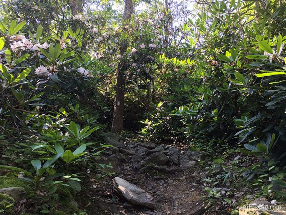
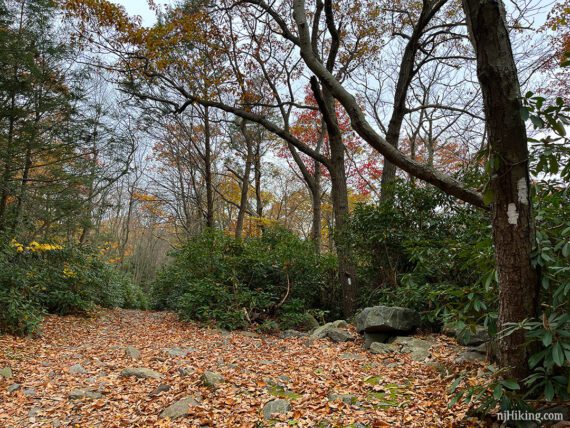
Climb steeply through a very long rhododendron tunnel. These are always so cool.
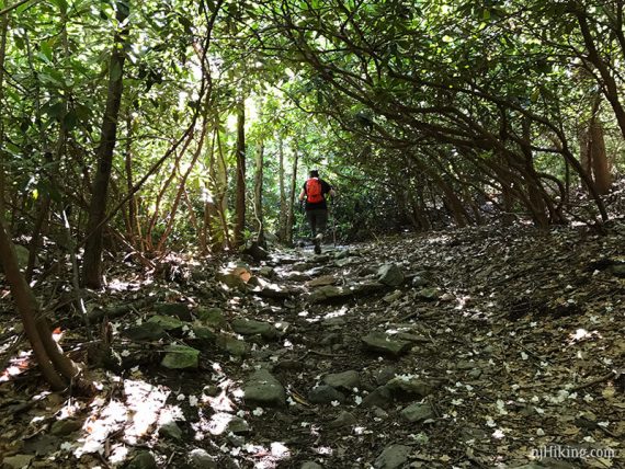
There are tons of rhododendron on the trails all around Mt. Minsi so this a great hike to do in July when they bloom.

1.8 – Cross the unmarked Mt. Minsi Fire Road/Lake Road by making a quick LEFT and then veer RIGHT to continue on the cleary Appalachian Trail (WHITE). [The Mt. Minsi Fire Road/Lake Road continues a bit further and loops around to end at the AT].
Take note of this intersection as the route returns to this point later.
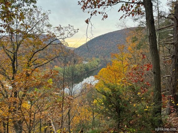
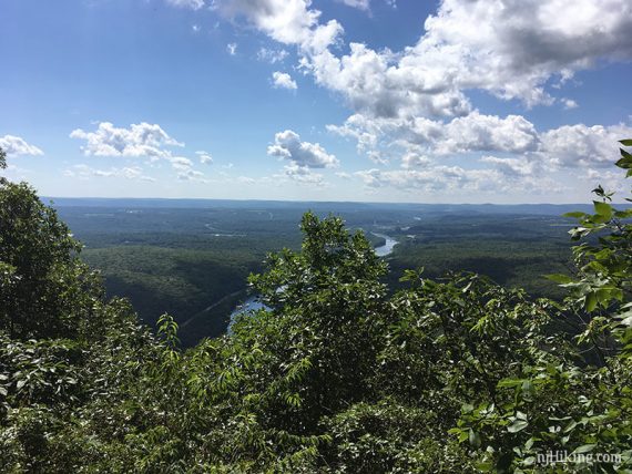
2.0 – Arrive at the 2nd overlook. This has the best views of Mt. Tammany. There is a smaller lower viewpoint and then as the trail continues up just a bit there is a more open area with a cluster of rocks for a slightly different perspective.
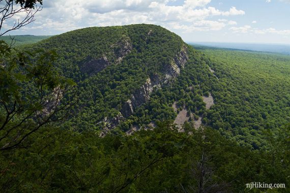
The valley below and beyond Mt. Tammany is also visible from this viewpoint.
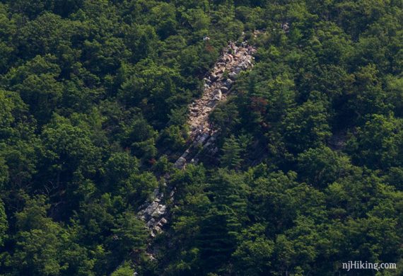
Have you ever hiked Mt. Tammany and scrambled down the rocks at the viewpoint? The open rocky area on the top right is where you were sitting:
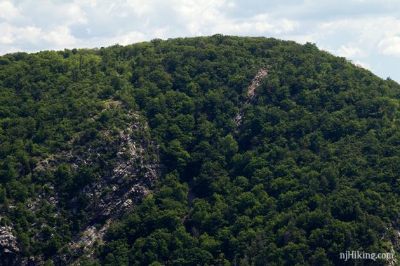
With a monocular, binoculars or a telephoto lens, hikers can be spotted on the rocky outcrop on New Jersey’s Mt Tammany:
// Shorter version, 4.0 or 4.5 miles round trip: Many people simply turn around at this viewpoint and return back on the Appalachian Trail (WHITE). OR turn around here and return via the Mt. Minsi Fire Road/Lake Road and it’s 4.5 miles. //
To continue to the 3rd overlook, continue following the Appalachian Trail (WHITE) steadily uphill.
Arrive at wide level area with a fenced building and radio tower and stone pillar and steps. There used to be a fire tower here and this is actually the summit of Mount Minsi. (Years ago there was a wooden “Mount Minsi” sign).
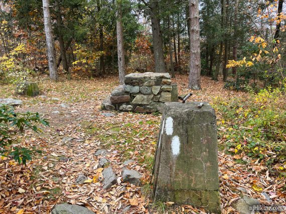
Follow the Appalachian Trail (WHITE) as it turns LEFT at the stone pillar and steps, passing the building and tower. The Appalachian Trail (WHITE) continues south and away from the summit of Mt. Minsi.
2.4 – Look for a side path on the left, marked with a VISTA sign, that leads out to the 3rd overlook. There are a few rocks to sit on for a break.

The Delaware River can be seen running between northwestern NJ on the left and PA on the right.
From this vista, retrace the side path out and turn RIGHT back on to the Appalachian Trail (WHITE).
// Longer Option: Instead, keep going on the Appalachian Trail as much as you’d like before turning around. It’s an easy woods road for awhile, then turns back into a trail. //
Retrace the route, passing the tower building and 2nd overlook again, to the junction with the Mt. Minsi Fire Road/Lake Road from earlier.
2.8 – Arrive back at the unmarked Mt. Minsi Fire Road/Lake Road. Turn LEFT and now follow that. [Appalachian Trail (WHITE) continues ahead].
// Variation, 4.6 miles total: Instead, stay on the Appalachian Trail (WHITE) and retrace back to the lot. This is steeper and rockier but some find this more interesting than the woods road.
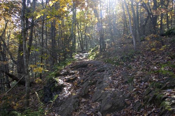
The Mt. Minsi Fire Road/Lake Road is unmarked but easy to follow. It’s wide, lined with rhododendron, and a gradual decline – but covered with chunky, loose, ankle-roller rocks. This can feel a tad tedious and dull but it’s less of a technical trail than the Appalachian Trail is.
4.0 – Pass an unmarked trail to Lake Lettini on the right… might not even notice it. Then in a bit pass the other end of it.
[Optional: Though it’s not really worth checking this out, the trail goes around a small lake that’s more like a swamp (well it was when we did it in 2011) and then meets back up with the AT.]
4.3 – Pass an unmarked trail on the left – OR see the variation described below. Continue on the Mt. Minsi Fire Road/Lake Road and eventually it becomes marked Appalachian Trail (WHITE) as it nears the parking lot.
Variation to Caldeno Falls and Table Rock
An unmarked trail leads to two cascades and a waterfall along Caldeno Creek on it’s way to a wide open flat rocky area called Table Rock, then continues to the back of Lake Lenape.
We prefer this ‘trail less taken’ route back, but be sure to have a trail map, preferably a GPS or mapping app, and be OK with navigating unmarked trails.
Notably, Kittatinny Trails from the Trail Conference shows the unmarked trail to Table Rock but not the trails to the cascade or falls – but this map would still get you there. We used GAIA but AllTrails also shows these trails. Waypoints for the cascades and waterfall are included on our Interactive Map.
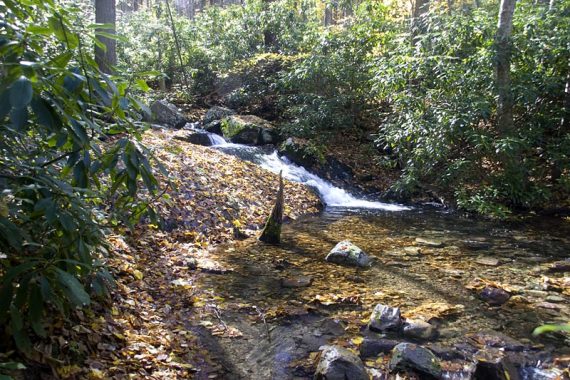
4.3 – Instead of continuing on the Mt. Minsi Fire Road/Lake Road, turn LEFT and follow a wide, gravel, unmarked trail. Shortly, take a side trail to the LEFT that leads to water cascading over rocks in Caledonia Creek.
We first wandered off via Table Rock in 2011 then again in 2017 and felt it was more enjoyable than the Mount Minsi fire road, even if it’s just replacing a short section of it.
Several years after our 2017 hike, one of our readers pointed out that we’d missed a waterfall. I thought they meant this cascade – which is pretty minor – but eventually looked into it.
We had returned to the main unmarked trail after this cascade – but the waterfall is off of the main trail (and not marked on the map we used). I made note for our next time… which didn’t happen until 2023 (so many trails, so little time).
From this cascade, start following the narrow trail running near the creek – don’t return up to the main unmarked trail. On GAIA and AllTrails this narrow trail is called “Green Trail” but we spotted no markers.
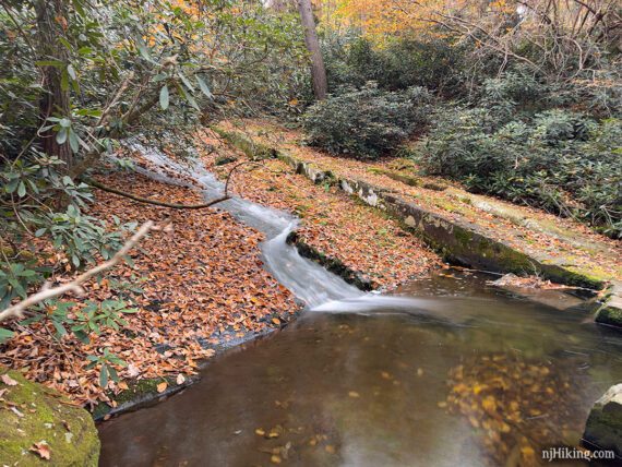
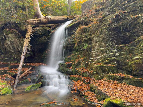
4.4 – Follow this tight trail and in a short bit come to a larger cascade flowing into a pool of water. Some of the rock is very straight like it was cut.
Continue as the trail gets a bit more technical as it approaches near the top of the waterfall. Carefully navigate the slightly dicey trail as there is a steep drop off from an overhanging edge. Scramble down a gully to a pretty little waterfall tucked into a rocky cove.
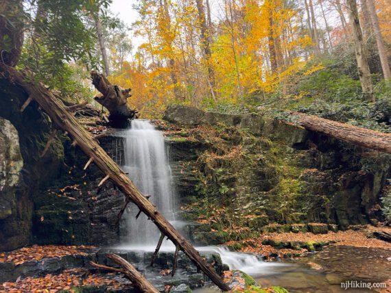
Rock hop across the creek to get a view from the other angle. It’s a nice little waterfall that was worth the side trip.
Climb out from the waterfall area and continue to the LEFT. [Maps show a trail straight back up but all we saw was scramble out of a rocky mess so we went left].
Fun Fact: Caldeno or Caledonia Falls? Mike at Metro Trails pointed out the creek has been incorrectly labeled as “Caledonia” on many maps, for decades. “Caldeno” is an amalgam of the names of the first non native people to discover the stream. See an old photo of Caldeno Falls and another showing the waterfall once had a path and stairs with a wooden railing.
4.5 – In a bit turn sharp RIGHT (the trail also continues ahead). Head uphill back to the original unmarked trail, and turn LEFT onto this. Alternately, the waterfall could be approached from this way instead of the narrow trail – it would miss the middle cascade but is an easier trail.
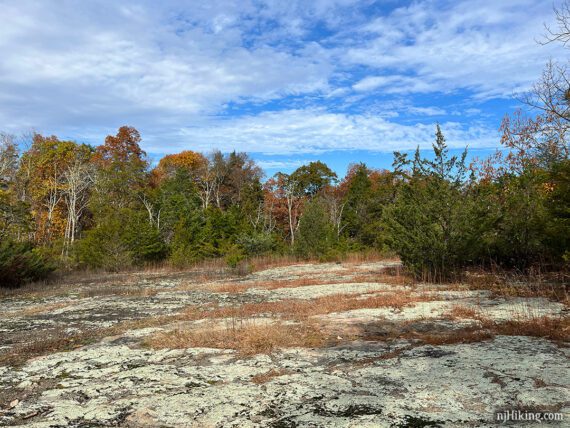
4.7 – Soon arrive at Table Rock – a very large flat rocky area with a fence along a drop off. Continue across Table Rock and pick up the unmarked trail. Off to the right you might spot the Mt. Minsi Fire Road/Lake Road below, through the trees.
5.1 – The trail approaches Lake Lenape from above and makes it’s way down to it. From the lake it goes left and right with both leading back to the parking lots. We’ve done both directions, most recently to the right which is probably a bit shorter but it did get narrow.
—-
Hiked: 10/27/23. variation with Caldeno Falls, Table Rock.
Hiked: 7/9/17. Trail Blog: “Mt. Minsi, Table Rock, Cold Air Cave, Slateford Falls“
Hiked: 10/9/11. Trail Blog: “Delaware Water Gap – Mt. Minsi, Arrow Island“
Hiked: 10/25/09. Trail Blog: “Mind the Gap” – Mt Tammany and Mt Minsi in One Day“
Hiked: 9/20/08. 16.6 miles. Trail Blog: “Delaware Water Gap – PA Side – AT South out and back“
Hiked: 10/31/04. Out-and-back, 8.3 miles, not quite to Totts Gap.
Updated: 5/2024 – Added shuttle info. 11/2023 – Refreshed page, added photos, added details for alternate return via Table Rock; re-hiked. 7/2023 – Shuttle info updated. 7/2017 – Re-hiked, added summer photos; description, GPX and Interactive Map updated.