This long route takes in Ramapo Lake, Van Slyke Castle ruins, plus views of the surrounding area and of NYC.
Ramapo Mountain State Forest, located in Bergen and Passaic Counties, contains a popular, extensive network of trails. It’s easy to create loops of any length and there is a lot to see, even on a short loop.
** Looking to hike to the castle ruins?! ** Use our guides for the Van Slyke Castle Loop (3.1 miles) or the Grand Castle Loop (5.6 miles).
!! IMPORTANT!! There have been major changes to trail names/colors in this park. The description below has been updated to reflect this but NOT re-hiked to check.
ALSO, the very end of this long route uses the Todd Trail to return to the parking lot and this is no longer shown on the trail map. You’ll need to decide to follow different trails back that will increase the mileage OR try to use the old trail.
For these reasons we recommend only experienced hikers use this particular page – most hikers will want one of the hike guides listed above.
10 miles. Moderate trail surface, many moderate elevation changes. Popular shorter options are indicated in the description below.
| 10 miles | This hike guide: Detailed instructions, photos, and video follow below. |
| Shorter | 1.2 miles round trip – Ramapo Lake Spur (BLUE/BLACK) to Ramapo Lake. You can also go around the lake on an easy woods road or pick up many other trails from the area. (About 1.2 miles RT to the lake, more if you wander around the lake) |
| Shorter | 3.2 miles round trip – Ramapo Lake Spur (BLUE/BLACK) to Ramapo Lake Loop (BLUE) to WHITE (Castle) up a bit of steep climb to the ruins of the Van Slyke Castle and water tower. |
| Nearby, same lot | Wanaque Ridge Trail |
| Nearby | Ramapo Valley County Reservation; Pyramid Mountain; Apshawa Preserve; Torne Mountain/Osio Rock; Norvin Green – Wyanokie High Point; High Mountain; Paterson Great Falls |
Our two cents:
This is a very, very popular area, especially going to and around the lake. But the further you hike away from the lake/castle area, the less crowded this park becomes.
The long loop is only for experienced hikers in decent shape, and there are a lot of trail intersections to navigate. Busy Skyline Drive must be crossed twice. While not quite as bad as Frogger, it can be tricky nonetheless.
Parts of the route does suffer from road noise. Many of the photos in this guide are older and from before the castle ruins were covered in garish graffiti.
Fun Fact: Van Slyke Castle is called “Foxcroft Mansion”in the The New Jersey Walk Book (p.93) while online sources refer to it as Van Slyke Castle.
Updated: 2/2026 – Minor edits, not-rehiked. Older change log at page bottom.
Hike Info:
Map/Books:
Northern New Jersey Highlands Trails Map is recommended to navigate the network of trails in this park.
Good, short or moderate length hikes that includes the castle (with a trail map diagram) are in 50 Hikes in New Jersey, Best Day Hikes in New Jersey, Hike of the Week and Take a Hike New York City.
A longer route and map diagram can be found in 60 Hikes Within 60 Miles: New York City, and trail descriptions can be found in The New Jersey Walk Book.
Parking: N41.03247° W74.25218°
Ramapo Lake Trailhead. 67 Skyline Dr, Oakland, NJ 07436.
Rt 287 to Exit 57, north on Skyline Drive briefly – the “lower” parking lot is on the left, there is a large wooden sign but it comes up kind of suddenly.
The entrance is pretty rutted, so take it easy if you have a low-clearance vehicle. This popular trail head lot fills up quickly.
There is another parking area further north on Skyline drive – the “upper” lot.
Restrooms:
None, but it might have a portable toilet. Various stores in Oakland, Wayne etc.
Hike Directions:
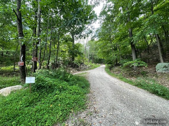
At the far end of the parking lot, walk toward the trail and stone wall ruins to pick up Ramapo Lake Spur (BLUE/BLACK).
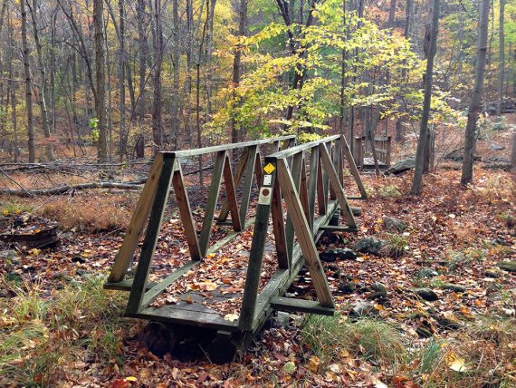
The trail is immediately very pretty – the shady trail wanders near a stream and gently heads uphill towards the lake.
The trail is very rocky, with a minor half-scramble and then an easy rock hop over a small stream. [Streams may be seasonal]
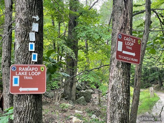
0.6 – Castle Loop (WHITE) comes in on the right. Soon after start following Ramapo Lake (BLUE) ahead, which is co-aligned with Castle Loop (WHITE).
[Ramapo Lake (BLUE) also goes to the left. If you cross the dam you’re going in the wrong direction.]
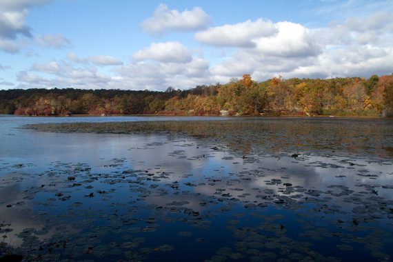
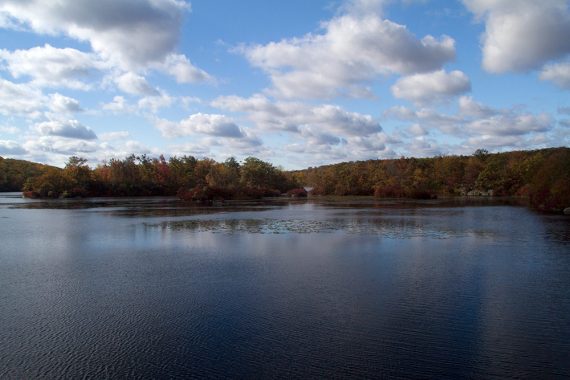
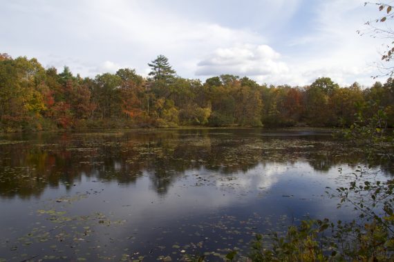
Continue following Ramapo Lake (BLUE) on an easy dirt road as it hugs the north side of Ramapo Lake.
There are many spots to sit and/or view the lake.
// Shorter option – 1.2 miles round trip: Turn around here for an easy hike, or go around the lake all or part-way for a short loop. //
1.1 – Veer RIGHT at a wide intersection with signs for the castle and lake. [Ramapo Lake Loop (BLUE) continues ahead and goes around the lake].
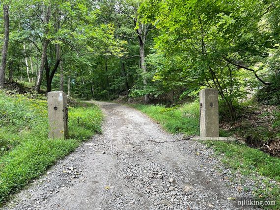
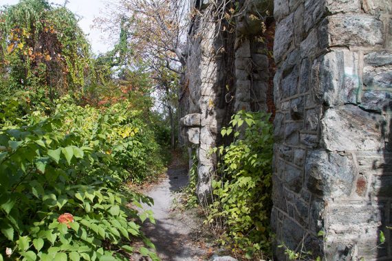
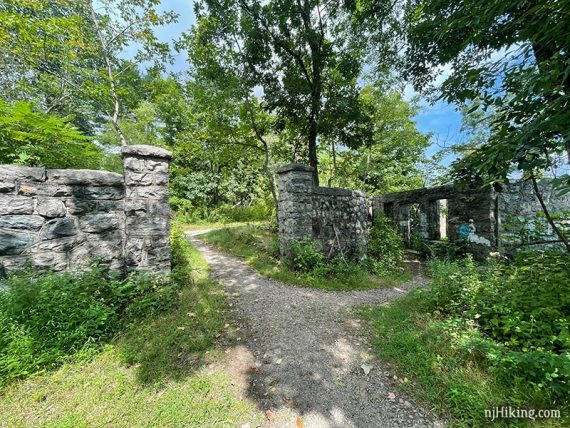
Head uphill through 2 stone posts.
Cannonball (White C on Red Circle) briefly joins in from the left as Castle Loop (WHITE) curves to the RIGHT. Follow Castle Loop (WHITE) to the LEFT. [Cannonball (White C on Red Circle) continues ahead but was unclear.]
Castle Loop (WHITE) becomes very rocky and heads steeply uphill.
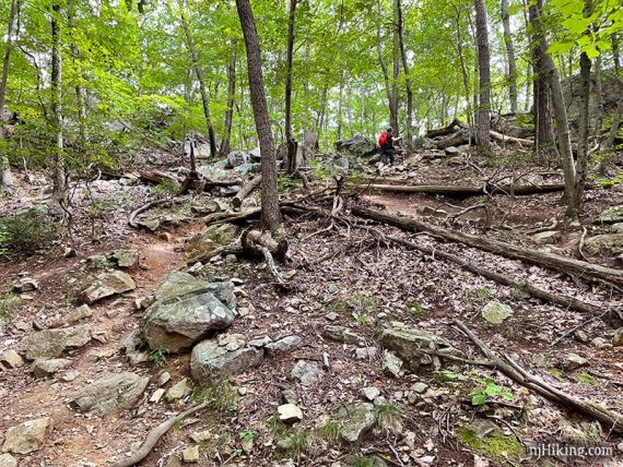
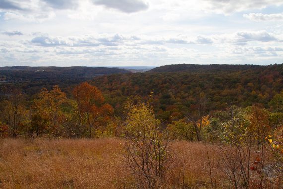
Head uphill, steeply and climb a wooden stile scramble over a low stone wall. On a clear day the NYC skyline may be visible behind you.
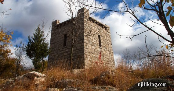
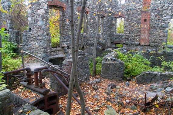
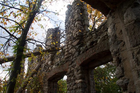
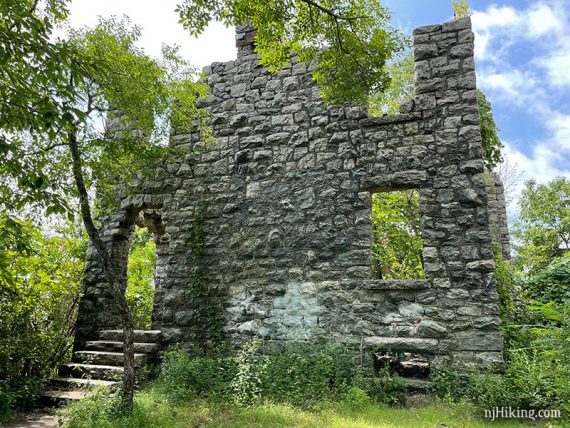
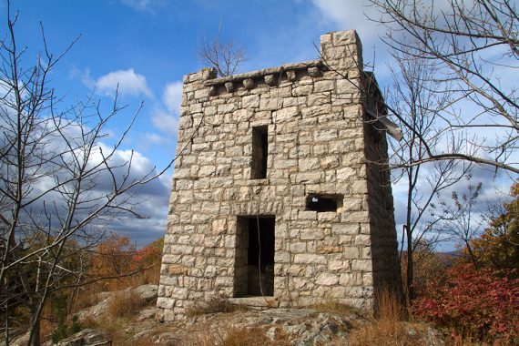
1.4 – Arrive at the remains of the Van Slyke Castle – basically stone walls and some pipes. [When we hiked this in 2009 the area was overgrown and filled with poison ivy].
Looking inside the walls of the castle ruins:
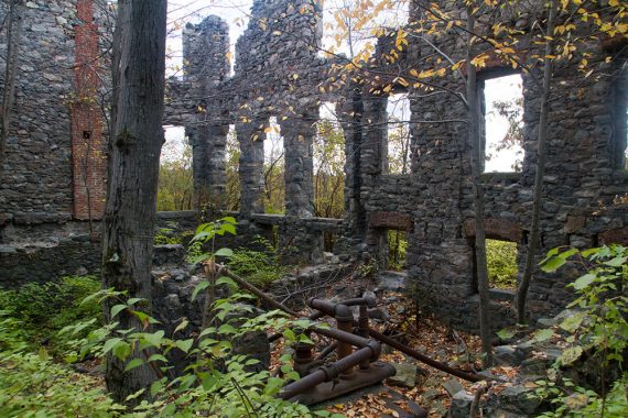
Looking up at the stone walls of the castle:
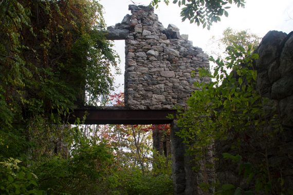
The path splits after walking around the side of the ruins. Head to the right where stone pillars and wall flank the path.
The back of the mansion has steps and a large section of intact wall.
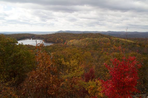
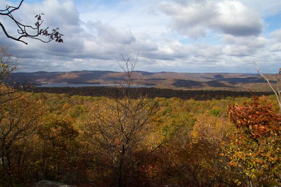
Continue on Castle Loop (WHITE) to another viewpoint on the left, overlooking Wanaque Reservoir in the distance. Also pass the ruins of a swimming pool for the mansion.
View on the way to the water tower:
1.6 – Arrive at a large stone tower that used to hold a water cistern for the mansion.
There are views of NYC on a clear day to the east. You may need to walk on the rock outcrop a bit and peek through the trees [2021: Overgrown and couldn’t locate the view from 2013 in this area].

// Shorter option – 3.2 miles round trip: Turn around and retrace your steps. //
Continue on Castle Loop (WHITE), passing various viewpoints on the left.
1.8 – Continue on Castle Loop (WHITE) as the route makes several turns. The trail briefly turns right onto a wide sandy road for a pipeline. Cross a stream.
2.2 – One last short push uphill on a rock slab. Castle Loop (WHITE) ends at a paved path. Turn LEFT and start following Cannonball (RED circle with a WHITE C). Immediately cross Skyline Drive.
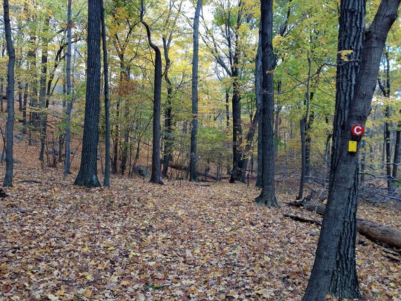
2.3 – Continue following Cannonball (RED circle with a WHITE C) as Hoeferlin trail (YELLOW) comes in from the right and is co-joined now.
The trail is an easy woods road but is parallel to Skyline Drive so there is a lot of road noise.
2.9 – Open area for a pipe line. The blazes are not immediately obvious, look for some large cement blocks straight ahead on the other side of the clearing and there will be blazes there.
Continue following Hoeferlin (YELLOW)/Cannonball (RED circle with a WHITE C).
3.3 – Continue straight on Hoeferlin trail (YELLOW)/Cannonball (RED circle with a WHITE C) as Matapan Rock (RED) crosses left and right. The trail now veers away from the road so the road noise lessens.
3.9 – Trail splits in a Y. Bear RIGHT on Cannonball (RED circle with a WHITE C). [Hoeferlin (Yellow) goes to the left.]
4.7 – Intersection with Old Guard (GREEN LEAF on WHITE). Turn RIGHT following the very briefly co-joined Old Guard and Cannonball.
Arrive at a T and turn RIGHT and start following Old Guard (GREEN LEAF on WHITE). [Cannonball (RED circle with a WHITE C) goes the left].
You almost half-way in this route; now turning south back towards the parking lot. Cross the pipeline cut.
4.9 – Watch for the blazes indicating a RIGHT turn for Old Guard (GREEN LEAF on WHITE) where a woods road goes straight.
5.3 – Continue following Old Guard (GREEN LEAF on WHITE) which is now also Schuber (ORANGE).
There may be a stream you can take a break by in this area. [Schuber (ORANGE) also goes to the left.]
5.5 – Camp Glen Grey buildings are in this area. Continue following Old Guard (GREEN LEAF on WHITE) as Schuber (ORANGE) turns right and crosses the water on a bridge.
Continue straight on Old Guard (GREEN LEAF on WHITE), following Fox Brook in a pleasant area. The trail may be hard to spot as it weaves through the trees.
There are some picnic tables in the camp.
5.9 – Lake Vreeland comes into view. Continue to follow Old Guard (GREEN LEAF on WHITE) which is on the camp road.
Pass a dam and another camp building before arriving at a gravel parking lot. Bathroom buildings here were locked.
Walk through the lot and past the buildings and look for Millstone (WHITE) on the left.
6.2 – Turn LEFT and start following Millstone (WHITE), crossing the stream on a bridge and heading away from the Camp and through some shady, pleasant forest.
6.4 – Turn RIGHT and follow YELLOW (Diamond)/Millstone (WHITE). [YELLOW (Diamond) also goes left]
Cross Fox Brook on two bridges, then cross Midvale Mountain Road. Head uphill.
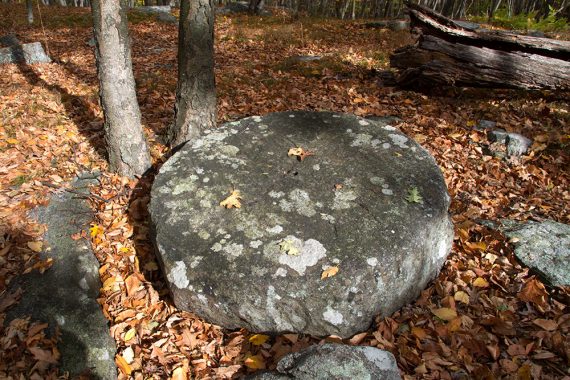
6.9 – Old millstones are laying on the ground, and this makes a nice rest spot.
At this point, Millstone (WHITE), and YELLOW (Diamond) split; start following only YELLOW (Diamond) now.
The trail becomes quite narrow and overgrown with tall grass. There are some views of the surrounding hills in the area as well as NYC in the distance, though mostly obscured by trees.
The trail starts to head downhill.
7.5 – Rock-hop the first of two stream crossings (or, they may be dry), then start heading steeply uphill. At the top of the hill, a blue water tower is visible in the distance. Continue following YELLOW (Diamond).
**From this point on the trails/map are different than when we hiked this route and we’ve done our best to adjust the description. **
8.1 – YELLOW ends before arriving at Todd Lake.
Start following Tamarack Loop (PINK) STRAIGHT (or it may be more of a LEFT). [Tamarack Loop (PINK) also goes right.] Pass Todd Lake.
8.2 – Once past the lake, Tamarack Loop (PINK) comes to Todd Hill Loop (GREEN) (should be a woods road) and it’s here you’ll need to make a decision.
Option 1 – Follow the new trail map. Continue on Tamarack Loop (PINK), following it to Skyline Drive. Cross Skyline Drive into the Upper parking lot. Start following Castle Loop (WHITE) ahead. [Castle Loop (WHITE) also goes to the right as it’s a loop from here.] Turn LEFT onto Ramapo Lake Spur (BLUE/BLACK) and return to the parking lot.
Option 2 – Follow this original hike route. No guarantees it still can be followed. Where Tamarack Loop (PINK) comes to Todd Hill Loop (GREEN), turn LEFT onto Todd Hill Loop (GREEN). Past a viewpoint you’ll need to find the old Todd trail (WHITE) – which may or may not be blazed or even possible to find.
Follow the rest of the original description from this point.
9.1 – Cross Skyline Drive. Traffic can be heavy and the other side has little shoulder to stand in while hopping over a guard rail. Continue following TODD (WHITE).
9.6 – Meet up with Ramapo Lake Spur (BLUE/BLACK), where you where earlier. [TODD (WHITE) ends] Turn LEFT and retrace Ramapo Lake Spur (BLUE/BLACK), back to the lot.
—
Hiked: 10/25/13.
Hiked: 7/12/09. Trail Blog: “Ramapo Mountain State Forest – Van Slyke Castle“
Hiked: 3/15/09. Variation. Trail Blog: “Ramapo Mountain – Hoeferlin & Cannonball“
Updated: 2/2022 – Trail map info. 9/2021 – Description updated with new hike names/colors – but NOT re-hiked to check. 5/2020 – Page refreshed, not re-hiked. 11/21/13 – Updated description and GPS file, added new photos taken in the fall. For spring photos, check our post from 2009.